Seismic engineering in Denver addresses the critical need to protect structures and lives from earthquake-induced ground shaking and associated hazards. While Colorado is not traditionally viewed as a high-seismicity state like California, the Denver Basin and surrounding Front Range region face a unique seismic risk profile. This category encompasses a comprehensive suite of geotechnical and structural engineering services designed to evaluate, mitigate, and design for seismic forces, ensuring that buildings, bridges, and infrastructure can withstand the ground motions expected during an earthquake. Understanding and applying these principles is not just a matter of regulatory compliance but a fundamental aspect of responsible development and long-term community resilience in the Denver metropolitan area.
Denver's geological setting plays a pivotal role in its seismic vulnerability. The city sits atop the Denver Basin, a deep structural basin filled with sedimentary rock formations underlain by crystalline basement rock. This basin geometry can amplify seismic waves, particularly long-period motions, which pose a significant threat to tall buildings and long-span structures. Furthermore, the region is crisscrossed by potentially active faults, including those related to the Front Range uplift. While the recurrence interval for large earthquakes is long, the presence of these faults means a significant event is possible. A critical secondary hazard, especially relevant in areas with shallow groundwater or river deposits like the South Platte River corridor, is soil liquefaction analysis, where saturated granular soils can lose strength and behave like a liquid during shaking, causing catastrophic foundation failure.
The regulatory framework governing seismic design in Denver is rooted in national model codes with local amendments. The City and County of Denver adopts and enforces the International Building Code (IBC), which references the ASCE 7 standard for minimum design loads. ASCE 7-22, the most recent edition, provides detailed seismic design criteria based on site-specific ground motion parameters. These parameters are derived from the U.S. Geological Survey's National Seismic Hazard Maps, which define the maximum considered earthquake ground motion. For critical structures, a site-specific seismic microzonation study may be required to refine these estimates, accounting for local geological conditions that can drastically alter the intensity and character of shaking across a project site. Compliance with these standards is mandatory for all new construction and substantial alterations, ensuring a baseline level of seismic performance.
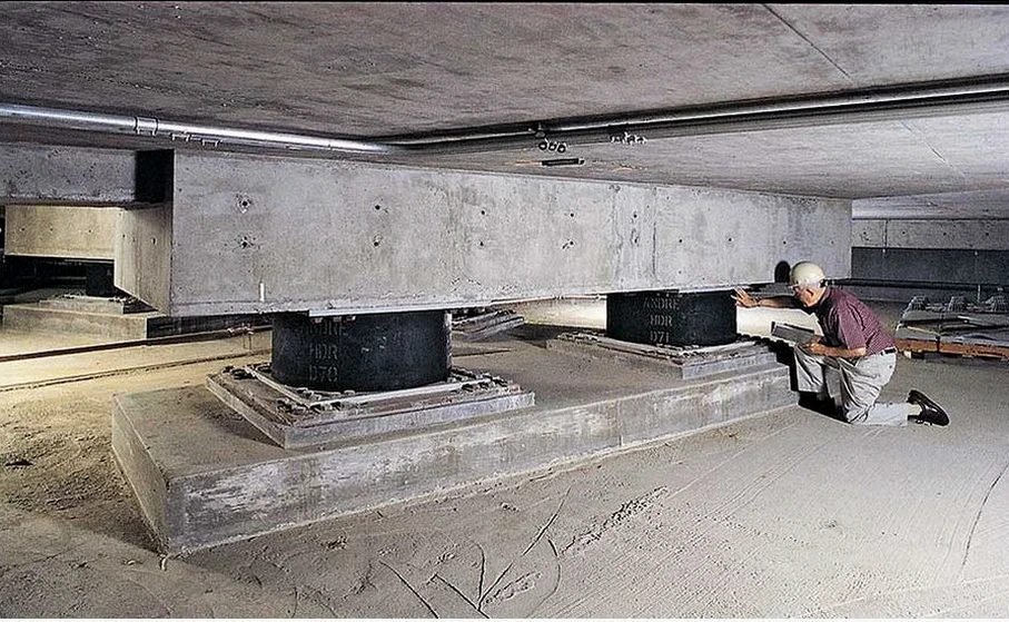
The types of projects requiring sophisticated seismic services in Denver are diverse. High-rise buildings in the downtown core and the Denver Tech Center are prime candidates for advanced analysis due to their sensitivity to basin-amplified long-period waves. Essential facilities, such as hospitals, fire stations, and emergency operations centers, must meet higher performance objectives to remain functional after an earthquake. Critical infrastructure, including bridges, water treatment plants, and utility systems, demands rigorous seismic qualification. For these high-importance structures, innovative solutions like base isolation seismic design are often employed, decoupling the structure from the ground to dramatically reduce the forces transmitted into it. Even standard commercial and residential developments, particularly those on soft soil sites, benefit from thorough seismic hazard evaluations to inform foundation design and structural detailing.
Common questions
Is Denver at a high risk for a major earthquake?
Denver is classified as having a moderate seismic hazard. While not as active as California, the region has numerous faults and a deep geological basin that can amplify shaking. A large, damaging earthquake is possible, though less frequent. This makes engineered seismic design essential for protecting long-span and tall structures from the specific ground motions expected here.
What is the governing building code for seismic design in Denver?
The City and County of Denver enforces the International Building Code (IBC) with local amendments. The IBC references ASCE 7, which specifies seismic design criteria based on USGS national hazard maps. This code defines the minimum required strength and detailing for structures to resist earthquake forces, with stricter requirements for essential facilities.
Why are site-specific seismic studies important if the code already provides maps?
Code maps provide a general, smoothed overview of regional hazard. A site-specific study, like seismic microzonation, accounts for local geological conditions—such as basin effects and soil type—that can drastically amplify or de-amplify shaking. This is critical for tall buildings in Denver's basin setting, where long-period ground motions may be significantly stronger than mapped values indicate.
What secondary seismic hazards should be considered for a Denver project?
Beyond ground shaking, the primary secondary hazard is soil liquefaction, especially in areas with shallow groundwater near rivers and creeks. Lateral spreading on slopes and potential fault rupture near known lineaments are also considerations. A comprehensive geotechnical investigation will identify which of these hazards are present and require mitigation measures in the structural and foundation design.